Building Delgovicia
The Roman Fort and Town of modern-day Malton and Norton in Minecraft
This project was for my MSc Digital Heritage dissertation and is titled ‘Building Delgovicia: A Practice-Based Investigation into Minecraft, Social Media, and Public Engagement with the Roman Fort of Malton, North Yorkshire.’
Summary | Aug 2026
I’m currently finishing my MSc in Digital Heritage, and for my dissertation, I have been creating a reconstruction of the Roman fort at Malton in North Yorkshire in Minecraft. Its Roman name was probably Delgovicia, and this summary covers how I built it, from the raw elevation data through to this first version of the complete fort. The current version is definitely not finished, but my dissertation is due in three weeks, so this is the reconstruction for now. You can download the map above, and if you’re reading this soon after publishing, the survey feeding into my research is still open.
Why Malton?
Malton and Norton were home to a Roman fort and a civilian town. Malton is actually the oldest Roman town north of the Humber, just older than York, and served as a base for an auxiliary cavalry regiment. However, most of it is invisible today, and very little has been excavated. The remains lie under roads, houses, fields, and even a Norman castle. The north-east half of the fort lies beneath what’s now Orchard Fields. The civilian settlement, the vicus, spread along both riverbanks and out along six converging roads, probably covering the whole of modern Norton.
Malton Museum holds incredible Roman finds from the site and surrounding area. This project aims to rebuild the fort in Minecraft to be an interpretation aid to help visualise what it may have looked like and explore how documenting the build process publicly, like this very post, can be a form of public engagement in its own right.
I’m not a Roman archaeology expert; I’m approaching this from a public engagement perspective. I did something similar for my undergraduate dissertation, building a game based on the Neolithic site at Avebury.
How do you start rebuilding something you can’t really see? I started with the ground itself…
The Ground
LiDAR (Light Detection and Ranging) fires lasers from a plane or drone and measures how long they take to bounce back, mapping the terrain in great detail. The last return of these lasers points builds a Digital Terrain Model, filtering out buildings and vegetation to reveal the bare earth beneath. In archaeology, this reveals earthworks hidden under fields and undergrowth. You may have heard of this technique being behind discoveries of Mayan settlements hidden under rainforest canopies.
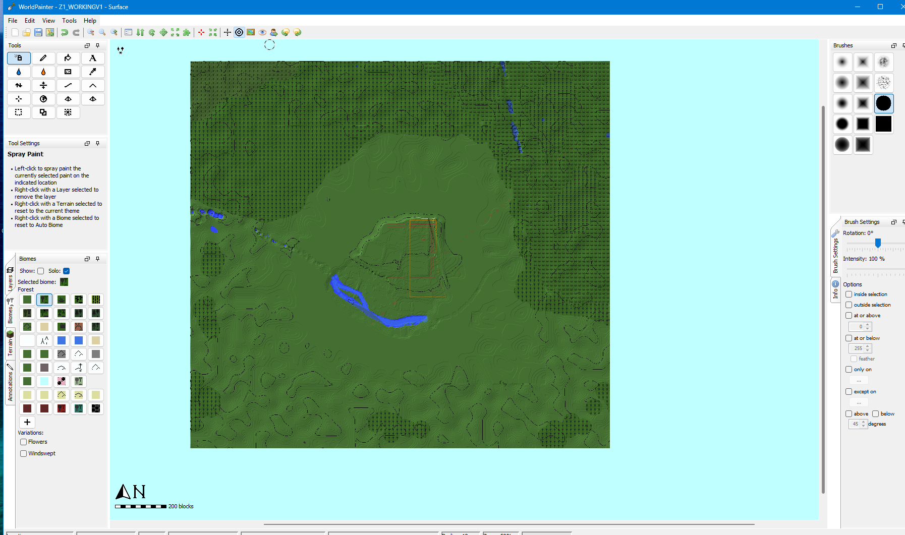
I imported LiDAR data of the area into ArcGIS Pro to create a height map of the fort site down to the river. Since I’m building at a 1:1 scale (one Minecraft block=one real metre), getting accurate real-world terrain felt like the logical first step. This height map was then imported into Worldpainter, an interactive map generator for Minecraft Java that lets you turn real elevation data into a playable landscape. Once the height data was in, I added a yellow boundary around the modern area you can visit today, where the earthworks are still visible. That means the finished world shows both: the fort as it was, and the part you can go and walk over right now.
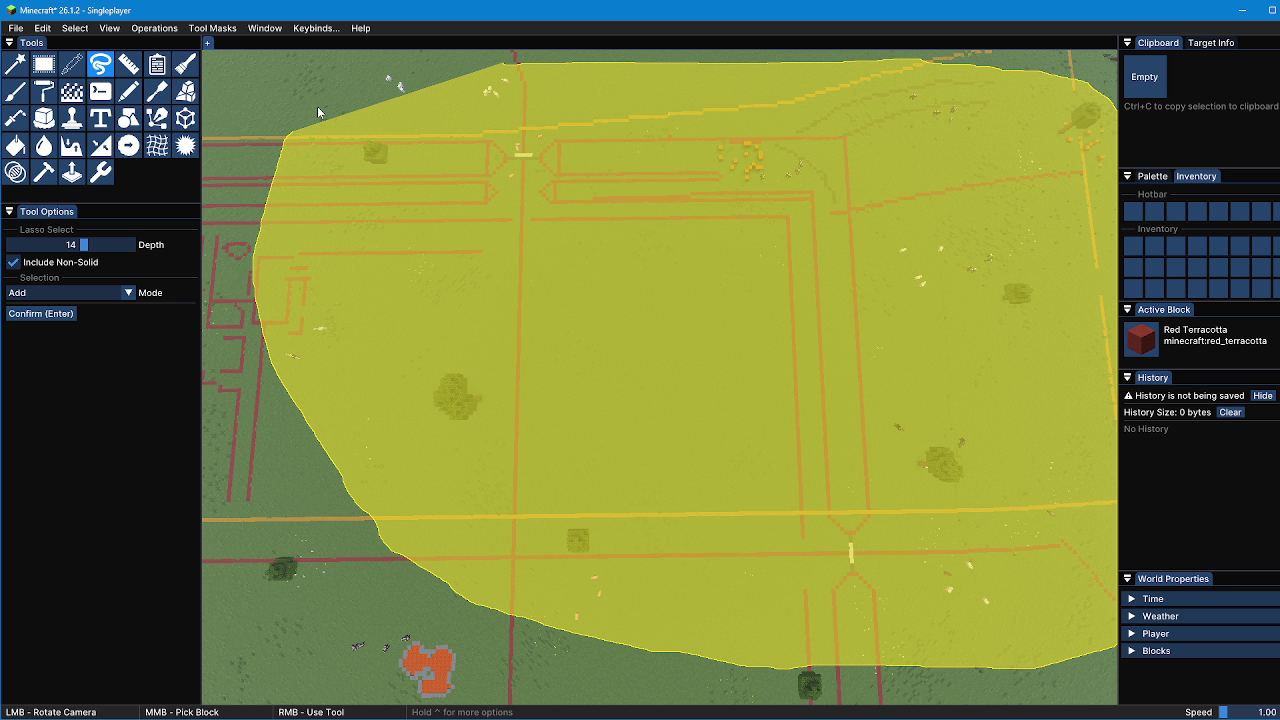
Next, I added an overlay image of the fort’s plan and traced it directly onto the landscape. Then it was all about tidying up: smoothing the area of the fort, adding biomes, and creating the proper canvas to build on. Once imported into Minecraft, I installed the mod Axiom to aid the building process, an all-in-one world editing tool that adds capabilities similar to traditional 3D software.
Research
Before any building could begin, I needed to gather resources and information to make design choices based on as much evidence as possible.
Aside from some trenches dug in 1865-66 during construction of the railway, no systematic excavation of the Roman fort at Malton took place until 1927. Philip Corder excavated the site in the late 1920s, focusing on the fort’s north-east gate, and published his report in 1930. Before that, the exact position and extent of the fort were unknown (only 99 years ago!).
Geophysical surveys help too: a non-destructive technique using equipment like magnetometers, ground-penetrating radar, and earth resistance meters, letting archaeologists effectively see beneath the soil. I spotted a geophysics report mentioned in the museum guidebook, and managed to track down the full 2007 report. kindly sent over to me by one of the original creators, via LinkedIn. An absolutely incredible resource.
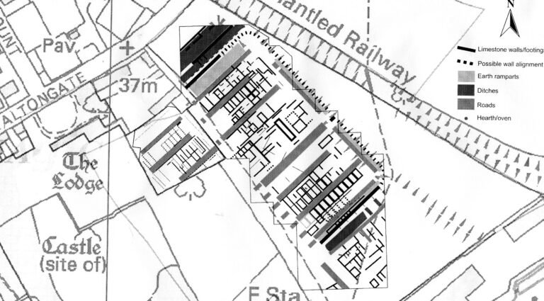
Interpretation of geophysical survey data from Malton Fort.
Reference books were also very valuable. Buildings of Roman Britain reconstructs a range of structures from plans, helping recover what Roman Britain may have looked like. Plus googling for reconstruction drawings and other plans, assembling them in a virtual whiteboard like a detective. Hudleston’s 1962 The History of Malton and Norton is also a comprehensive local history book that covers the Roman period of the town in great detail.
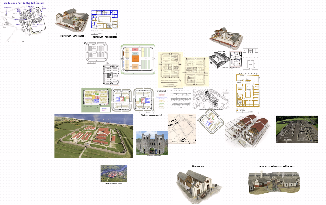
All of this came together to form a basis of evidence to make a plan and design decisions based on.
The Defences
I’m reconstructing the fort as it would have looked around the 4th century AD. This choice was partly inspired by a townhouse near the fort’s entrance that really caught my interest, where a mosaic was discovered in 1949. This period also appealed to me because it’s less systematic; after hundreds of years of activity on the site, things get a bit more chaotic.
By this period, Malton’s defences had been upgraded, featuring a double ditch and extended ramparts leading up to a stone wall. The fort’s permanent earth ramparts were at least 30 feet, or 9 metres, wide. They stayed tall enough to hide a man on horseback right up until 1900, when they were finally levelled. These earthworks are what still survive in the park today: the shapes you can see and walk on when you visit.
The north-east gate, the porta principalis sinistra, was carefully excavated by Corder in the 1920s. Originally, it was a double-portal wooden structure. But when the fort walls were rebuilt in stone, this entrance was reformed, with single inner and outer arches, with a central chamber flanked by two guard rooms. A great surviving example of a similar design is at Cardiff Castle. As I’m building the fort as it looked in the 4th century, I didn’t want it to be pristine, so I ensured to use a range of brick options like mossy, cracked bricks and wall blocks to show decades of use as defensive structures.
Roads
Roads are what the Roman Empire is famous for. After the Roman invasion of Britain in 43 AD, the army rapidly built a network of roads linking the most important military sites. Malton was a major crossroads; about six Roman roads converged here, connecting the east coast all the way to Eboracum, modern-day York.
Around Malton, the roads leading through the fort gates were well-made of stone, concrete and gravel with ruts in them 4 feet 9 apart. They also had a curved surface to allow rain to run off them into side ditches. I’ve used stairs and slabs to create the curve and ditches. Civilian buildings spread along all these roads in Malton. In the 3rd century near the south-east gate, some buildings were rebuilt up to 12 times, with the roads re-laid almost as often.
Filling in the Fort
With the roads down, it was time to lay out the internal buildings, which is where things started to get difficult. I’ve been using the geophysics plan to figure out where everything goes. However, Geophysics shows you that something’s there, not what it is. So a lot of this is educated guesswork, based on typical Roman fort layouts, which, luckily, there are a lot of other examples. Another, however, the plan only covers about ¾ of the fort site. That’s because the pesky Normans turned up hundreds of years later and built a castle on top of that part of the site.
The geophysics does clearly show roads, which were likely symmetrical, so I started laying those out first. Next, the principia, the headquarters building, goes right in the centre, as is typical of Roman forts. The buildings around the centre also tend to follow a pattern, including the commander’s house, granaries, and a hospital. Sometimes workshops are found here too, and there’s a strip of what looks like hearths nearby on the geophysics, so I might place a row of workshops there. Most of the rest of the fort is filled by barracks. And since this was a cavalry fort, some of those barracks are actually stables. Then there’s the smaller stuff too, like ovens, latrines, and corner towers.
Principia
Located at the centre of the fort, the principia was the administrative heart. It featured a central courtyard, a basilica (large hall), offices for clerks, and a shrine that housed the standards and religious icons. Beneath the shrine, there was often a secure underground room, the aerarium, where the legion’s pay chest was kept. For the walls, I used red terracotta and white concrete; for the roof, I originally tried deepslate tiles before switching to red bricks. For this first phase of the project, I’m only focusing on building exteriors.
Granaries
Granaries were essential; they stored the fort’s food supplies, especially grain, with raised floors to prevent moisture from spoiling the food, thick walls for insulation, and good ventilation to keep everything dry. Every Roman fort was supposed to hold about six months’ worth of grain to make bread for its soldiers. This fort housed around 500 men, so that would be quite a bit of grain. Granaries almost always came in pairs as twin buildings sat side by side. However, at Delgovicia, the geophysics only clearly shows one granary next to the principia. There are some examples of single granaries. However, because of a gap, I made the decision to put two in, as is most typical. A lot of decisions like this come down to personal interpretation. I’m hoping to eventually share several versions of the fort, so if you fancy it, you could try placing buildings yourself and see if you agree with my choices.
Hospital
The hospital, or valetudinarium, was typically sited centrally, built around two main principles: access and seclusion. In their most elaborate form, they consisted of concentric rectangles of wards and corridors with double walls. These buildings are difficult to identify unless archaeologists find something very specific, like surgical equipment; it is hard to confirm a building was a hospital at all, as it may have been a workshop or a storeroom. One example comes from Housesteads on Hadrian’s Wall, with a courtyard surrounded by smaller rooms, a more open area possibly functioning as an operating theatre, and evidence of a latrine and plunge bath. While researching this section further for script writing, I came across a different reconstruction showing a second floor, so I think this build may need to be revisited.
At Delgovicia, I placed the hospital next to the granary; there is a gap roughly the right size, in a location I feel would be suitable, and it left enough space for a commander’s house on the other side. This is the building I’m currently least confident about, but it is a structure in place. If you happen to be an expert in Roman Britain fort hospitals, let me know!
Barracks
Most of a fort’s area was taken up by accommodation. The barrack blocks, or centuria, were built to house individual centuries of 80 men plus officers. Those 80 men were split into ten groups of eight, reflected in ten pairs of rooms running down each block, with the centurion and his assistants occupying a larger space at the end. This is where soldiers would have lived, with roughly eight to a room. Excavation evidence at some sites shows that women and children lived in these barracks as well. These felt small within the fort as I built them, but they were apparently usually around 50 meters, so I stuck with that scale throughout.
Stables
Stables are hard to identify archaeologically, but with so many auxiliary cavalry regiments stationed across Britain, many forts must have had them. One theory suggests that buildings resembling barracks in the archaeological record, but missing certain internal divisions, may have housed horses instead. They may also feature internal drains which would have kept the space drier and more hygienic with animals inside. For Delgovicia, I converted some barrack blocks into stables based on that reasoning.
A Renovation
I also deliberately blew up part of the fort, intentionally, not just dissertation frustration. This was in the north-east area, where excavations uncovered a late 4th-century building with an apse. The function is unknown; it may have been a high-status domestic building, a public building or even an early church. By blowing up one barracks block, I created this area as a building mid-transformation from a barracks block into this unique structure. I think small details like this bring reconstructions to life and demonstrate how the fort had a long, changing history. I would like to bring other details like this across the fort site.
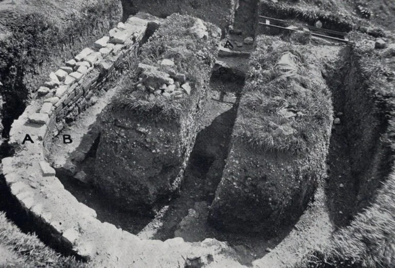
Apsidal building (A), showing earlier rectangular building (B) beneath. (Malton Museum)
Commander’s House
Almost every fort had a praetorium, a residence for the commanding officer and his family. These buildings were usually built in a Roman Mediterranean style, like the residence of Rome itself, inward-looking, with four ranges of rooms around a central courtyard. One example, which I used as the basis for this fort’s version, is at Vindolanda, an enormous building with private dining rooms, entertainment spaces, and its own bath complex, occupying as much space as 150 regular barrack rooms combined. I feel like these buildings would have been quite individual, based on the specific commander, and built to reflect Roman style and status.
Delgovicia Rebuilt
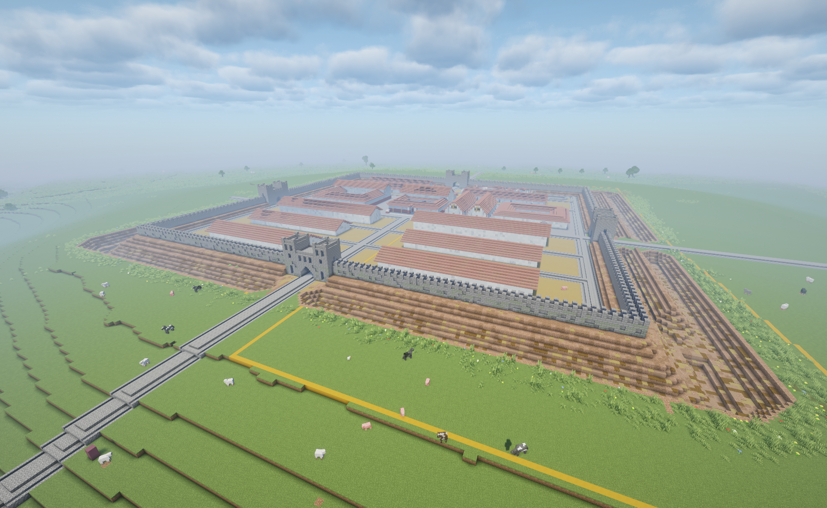
For now, that’s the fort building complete, and this is probably one of the few times Delgovicia has been seen in its full glory since antiquity: an important Roman cavalry fort in northern England, now hidden beneath a Yorkshire town. You can download this version of the fort yourself, and please fill in the survey.
One idea that comes up repeatedly in the literature, and resonates strongly with my approach here, is that accuracy isn’t the point. These models aren’t meant to be viewed as stand-alone, definitive representations; they are meant to be engaged with. The medium itself, in this case Minecraft, means precise accuracy isn’t really possible or even desirable; instead, the aim is for recognisable interpretations. Working without the pressure of producing an exact replica creates space to make creative decisions and explore the questions that emerge. This is an example of practice-based research, where the creative process itself is a method of inquiry.
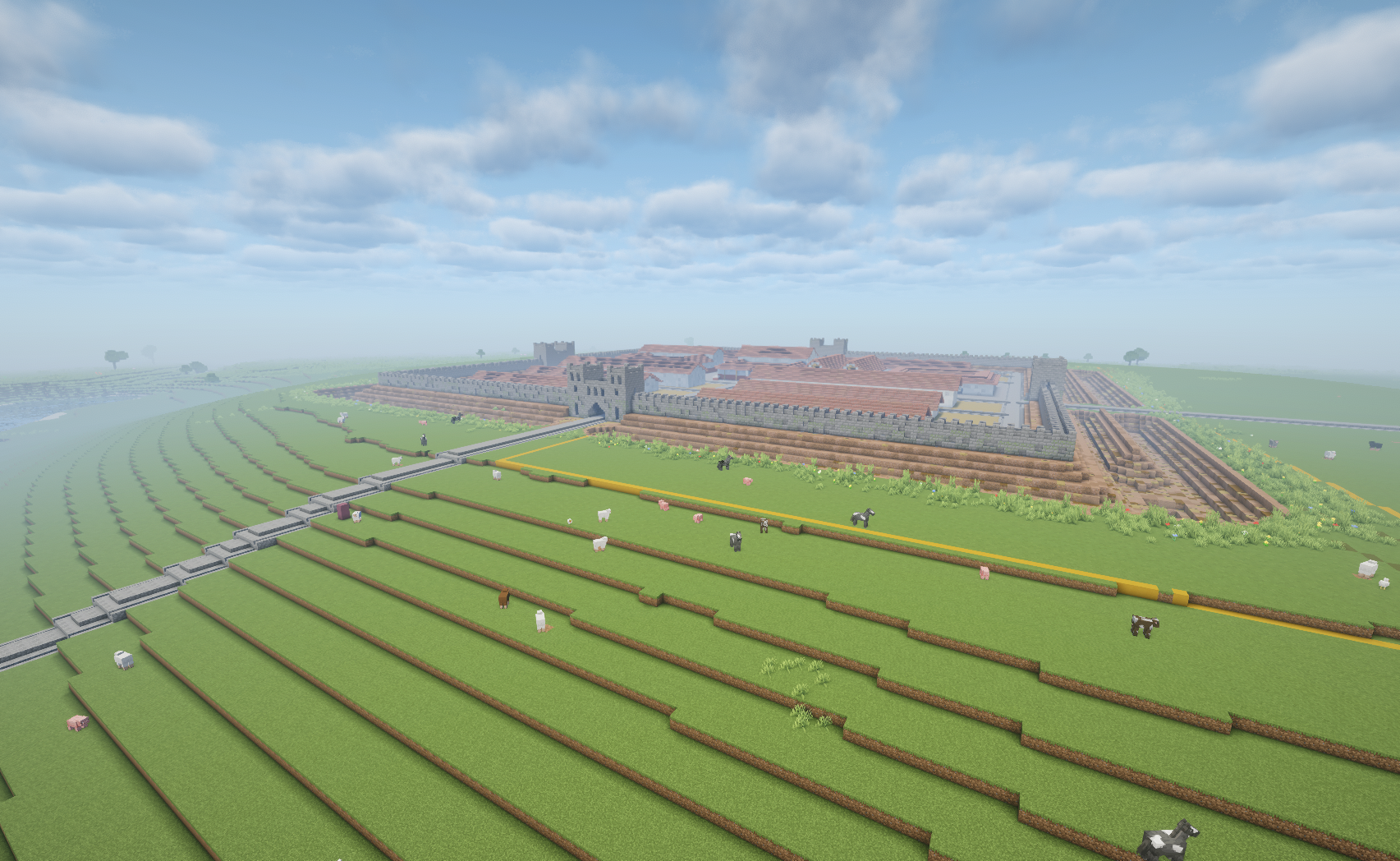
One of my favourite parts of the build is the yellow boundary marking the modern park, as it puts into perspective just how the fort actually was, and how much remains hidden today.
It’s a shame I haven’t had time to add the town, which would have sprawled out along all the roads; this can maybe be a project for another time, alongside adding building interiors.
What do you think should be next for the Roman Fort? What should I build next? Should I reconstruct somewhere from a different time period, or try a different game? Let me know and thank you for reading and for exploring the distant past with me.
References and Further Reading
Corder, P. and Kirk, J. L. (1928). Roman Malton: a Yorkshire Fortress and its neighbourhood. Antiquity, 2 (5), Cambridge University Press (CUP)., pp.69–82.
de la Bedoyere, G. (1991). The buildings of Roman Britain. London, England : Batsford.
Hudleston, N. A. (1962). History Of Malton And Norton.
Morgan, C. L. (2009). (re)building Çatalhöyük: Changing virtual reality in archaeology. Archaeologies, 5 (3), Springer Science and Business Media LLC., pp.468–487.
Phillips, J. and Wilson, P. (2021). Life, death and rubbish disposal in Roman Norton, north Yorkshire: Excavations at Brooklyn house 2015-16, Archaeopress Roman Archaeology. Oxford, England : Access Archaeology.
Wilson, P. (2017). Derventio, delgovicia and Praetorio: Some Roman-period place-names of eastern Yorkshire revisited. Britannia (Society for the Promotion of Roman Studies), 48, Cambridge University Press (CUP)., pp.305–308.
https://www.maltonmuseum.co.uk/2021/06/12/malton-roman-fort/